Surfing Waimea Alone
Two-wave Hold-down
Near-death Experience
| Hawaii Stories - Table of Contents |
Up on Bummer Hill. Crack of dawn. The light coming in through the slit in the one-foot-thick pillbox wall glared me awake.
I'm one of the Bunker Boys. Trolls living in abandoned World War II bunkers high atop the cliff overlooking the area between Log Cabin's and Off The Wall. No electricity. No water. Dumb haoles. I'd been in the Islands all of three months, straight from the flatlands of Florida. I had the little "one bedroom" bunker. Maybe all of six feet by ten. Jail cell sized. My buddies had the big multi-room split-level affair with the LSD-inspired "paint job" just to the west of my splendid isolation. Somebody said Owl lived there once. Who knows? Maybe he did.
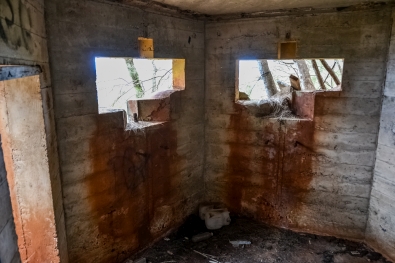
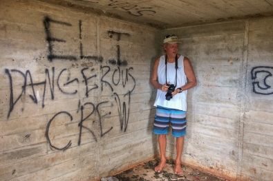
Here's what it looked like during the summer of 2015. It's well hidden. Almost impossible to get to. First time I'd seen it since 1973.
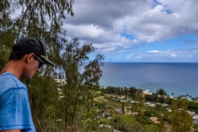 .
.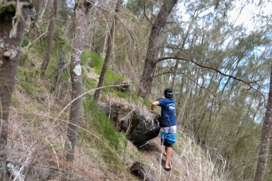 .
.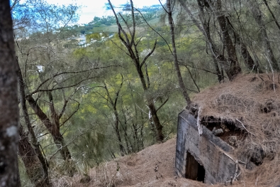 That's me, bottom-right. A lot of memories came flooding back. In certain very real ways, this was the best place I ever lived in my life.
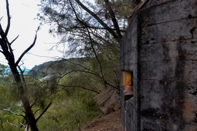 .
. .
.
Imagine that.
Ok, back to the story.
A look to the northwest and down has my immediate attention. Waves. Waves! Big waves! Yeah. Slight lump in the throat and quease-pit in the stomach. But nothing that's gonna derail today's surf, that's for damn sure.
Slug of water from the jug. Some uncooked oats with a teaspoon of sugar. Breakfast of champions. No sign of life in the other bunker. Screw them guys. Scramble down the cliff alone. Don't slip on the dew-slick rocks. Don't wanna fall off the cliff and die. Into the tall grass at the base of the cliff where the board's hidden. Still there. Good. And out to the Kam Highway we go, to hang our thumb in the breeze.
A weird-looking guy with gray hair stops to pick me up. Sakes alive! It's Dick Brewer. An idol, an icon, play it cool. "Where ya going?" "Waimea." A funny look is all I get. At the exact moment we drive past the place at Rockpiles where the gap in the trees lets you see the water, a gigantic wall of soup is pushing in about half way between the cloud reef and the usual Rockpile lineup. In the deep water where it's usually backed off, even on bigger days. A truly large wave. I look first at the wave and then at the man driving the car. He looks at me with an evil glitter in his eyes and a wolfish grin on his face. Through bad teeth all he says is, "The Bombora," and then resumes his driving.
We arrive at The Bay soon enough. At this early hour there's no traffic on the road at all. RB just stops right in the middle of the traffic lane and I get out and remove my surfboard from the car. "Thanks for the ride. Bye." "Bye." And that's it. My entire life's experience with Dick Brewer.
Standing there by the road, at the foot of the point, I can see the break. And it's breaking. Somewhere, shortly after arriving in the islands, I was given to believe, by people I trusted that I shouldn't have, that Waimea closes out at "fifteen feet." The waves are, as they've been every time the place has broken this winter, just about thirteen feet. Nice number. This is not the first time I've surfed Waimea, but it's the first time I've surfed it alone. There isn't a soul to be seen, anywhere.
The thought of having Waimea all to myself is mind-blowing. Amazing! Incredible! Impossible! But the waves are a shade disorganized. Despite the breeze whispering down the valley into the oncoming faces, they're a little bumpy and bobbley. But who cares? Pretty soon, when the sun comes over the hill, the whole world is gonna come swarming down here and ruin everything.
So I paddled out.
Alone.
At Waimea.
And it was just fantastic! It's breaking well out past the boil and just a moment or two to calibrate my lineups sets me right up on the spot. Wheeeee! Here comes a set. Pick a wave, any wave. Ride 'em cowboy! First one, then another, then another. This is too cool! The bump makes it a little squirrelly on the drops but it's nothing I can't handle. And still not a soul in sight. Nobody in the water. Nobody on the beach. Weird.
Wave number four approaches and I stroke into it with glee. At which point things begin to go seriously wrong.
Immediately upon coming to my feet, the board hits one of those bobbles coming up the face just so, and is instantaneously sideways. Splick! And suddenly the nose is pointing towards Haleiwa. Oh shit! Up there at the very top of the wave, there's nowhere to go but down. In a horrible skidding, skipping, bouncing slide down the face of the wave, entangled with the board (but without a cord, that came years later), I'm dropping down down down. As I tumble down the face with sickening velocity, the board keeps hitting me. Bump, thump, clunk. I'm praying to penetrate the surface of the water, to get under and perhaps away from, if only a little bit, the falling canopy of the lip. No joy. I'm still skipping and rolling as darkness descends upon me.
KaBOOOOOOOM!!!!
The initial force of the blast must have knocked me momentarily senseless because I have no proper recollection of it. My memory goes from skipping down the face with my board, directly to being thrashed around deep under water with nothing in between. I'm pretty sure there was something in between, but it no longer resides in my memory. I was now in some seriously deep shit but my first impression was one of relief. The board's gone! Instead of violently smashing into me, it disappeared. Good. But the thrashing is bad. Very bad. The best I've ever been able to describe it to anybody is by asking them to imagine a large dog with some kind of loose, floppy toy in its mouth and furiously shaking its head around tearing up the toy the way dogs will do. I was the loose, floppy toy.
The thrashing went on and on. I opened my eyes in the faint hope of orienting myself and perhaps finding a way out. The water was a darker shade of green than I'd ever encountered before. And the thrashing simply would not ease up. On and on it went. And with my eyes open, I watched the water go from a very dark and sinister green to an opaque black. Not good. As any fool knows, the water in Hawaii is nice and clear, giving good visibility. Not now. I remember thinking "Holy shit, I must be deep," as I strained my eyes to penetrate the blackness. The swirling, churning, blinding-white mass of soup above me had blocked every last photon of light coming down from above. The blackness below had taken on a frightening thickness and texture. My gothic reverie was rudely interrupted by an encounter with some lava.
I'd hit the bottom! It would have certainly have hurt, except for the continuance of the thrashing. My body was too occupied elsewhere to take much note of having just been slammed off of some lava rocks. It felt like a light bump. The thrashing went on, unabated. I'm now beginning to worry for my air. I'd been holding my breath and "relaxing" as best as I could to avoid burning up the pitiful store of oxygen in my lungs. I'm sure this was doing me a world of good but it certainly didn't feel that way. I was running out of air. As the terror of this evil thought percolated through my brain the blackness outside broke. The water had gone back to a sinister green. And even a pale green. Hallelujah! I was being churned back towards the surface. And not a moment too soon. My lungs had started in on the first little spasms of involuntary breathing action. Not much more than hiccups to start with, but I had to shut my mouth tight against the entry of any water. The water chose this exact moment to turn a beautiful clear, with light streaming down on me through gaps in the soup on the surface.
I was overjoyed. I allowed myself the luxury of burning some of my depleted oxygen in swimming towards the surface. The thrashing had stopped. I could see individual little bubbles of soup, floating on top of the water three or four feet above me.
And then the lights went out and the thrashing resumed with all its malevolent vigor. Oh God! Another wave! And just as I was about to take a breath of air! Damn! It's not fair! Down into the blackness I tumbled once again. Sonofabitch! My air was basically gone. I fought a panic rising in the pit of my stomach. Don't lose it now. Play it cool. The involuntary lung action kicked in to a higher gear. My lungs now had a mind of their own and that mind had only one thing on its mind. BREATHE! And so they did. Great heaves of intake which I could now not fully stop. Take a full mouth of water and swallow it. Repeat. The green blobs of light that flashed and shimmered in front of my closed eyes became brighter and then transformed themselves into a real technicolor display of failing neural activity. The thought popped into my head "Way to go dumbfuck, you've managed to get yourself killed by going out by yourself." For some reason, dying was made more annoying by not having anybody around when I died.
The involuntary lung action kicked up another notch and the panic rising in my stomach took control. I had the feeling of watching myself in a movie as I scratched desperately against the blackness, calmly knowing that I only had just a few more swimming strokes left in me before the wrenching in my lungs succeeded in taking a full charge of water. And, as if by magic, the thrashing stopped as though it had been turned off with a switch and I shot towards the surface on an upwelling column of water. I covered twenty vertical feet in a second, two at the most.
I broke the surface in an area mercifully free of thick foam and soup. My lungs, free from the insane stricture against doing their job, took in a tremendous gulp of air. And it was funny. Not ha ha funny, but weird funny. The air TASTED! Sweet! And not just a little sweet either. Did you ever, as a small child, eat a whole teaspoon of granulated white sugar? An electric jolt of sweetness, no? That's EXACTLY what that first gulp of air tasted like. Exactly. The shock of that sweetness was more than enough to grab my attention despite my expended condition. Breath number two tasted like nothing at all. Air. Good air. Lifegiving air. Odorless, colorless, and tasteless. Ever since. I've never tasted air again in my life. Nor do I wish to.
As I lay there in the water, just floating, I looked around. Another jolt! I'm inside! All the damn way inside! I had covered the full length of the break underwater without swimming a stroke! Holy shit! That second wave that hit me was the last one in the set and there were no more coming toward me. I could just lay there in the water and relax. Ahhh. Nice. I'm alive. Finally I turned toward the beach and swam in. Didn't have too far to go. The shorebreak was just as cooperative as it could be. Splish splash swoosh and I'm feet down on sand, walking over to where my board's washed up.
A glance down at my legs revealed that I'd taken a pretty good lick against the bottom. Both knees and lower legs were bright red with blood flowing from a host of cuts, none of which, thankfully, were particularly deep or nasty. Although, at the time, I couldn't have cared less if I'd looked down and seen my kneecap hanging out. One little dimple of a scar, above my left kneecap, is all that remains to this day to remind me of how hard I'd banged off the bottom, outside at Waimea.
I looked over toward the parking lot and saw that the lifeguard on duty had just arrived and was setting up in his stand. I walked over to him and asked, "Got any bandaids?" as I looked first at him and then down at my brightly-colored legs. He seemed impressed with the hemoglobin. "Nope. Sorry." Just arriving as he was, he had missed my whole little adventure. Since I seemed to be reasonably alive and well, he showed no great concern for me. Not required. Just another dumb haole. I asked him if many people had been hitting the bottom "out there" lately? Yes indeed apparently more and more people were hitting the bottom at The Bay lately. I thanked him for his time and trouble and departed with my board back to the Kam Highway over by the point.
Excepting the lifeguard who had just arrived, there still wasn't a single person anywhere around. Nobody. I shrugged inwardly and set up shop at a good spot for hitchhiking. A car that didn't have Dick Brewer in it pulled to a stop for me. They took me back to where I could make the climb back to my bunker, commenting that the bloody legs were what caused them to pull over. Did I need to go to the hospital? No, thanks. The sun came up over the cliff.
That was not the last time I surfed Waimea, but it was the last time I surfed it alone.
Addendum April 18, 2016
While researching my "How Does Sunset Beach Work?" articles, I have come across something that I find very interesting and perhaps a little bit alarming, as regards some missing information about this story, which has always nagged at the back of my mind.
To wit: How big was it this day, anyway?
As things just so happen, this is the only day I ever surfed Waimea for which I have a precise date. New Year's Day is an easy enough thing to remember, and remember it I did.
So ok, so I have a precise date. So what?
Well then, if we have a precise date, could there perhaps be an archived bit of data somewhere that deals with the sea state on this particular day?
I have looked long and hard (but apparently not hard enough), for many long years, sifting through NOAA this, and Navy that, and who-knows-what the other.
No results. No answers. No information.
New Year's Day, 1973, is taking things back a pretty good ways into the dawn of proper instrumentation on the data buoys that we all more or less take for granted now, and I just figured that for this time, and this location, nothing was in place, nothing was recorded, and nothing now exists by way of proper documentation.
Until this morning.
When I finally found a tangent remark about something called "the Goddard and Caldwell (GC) set" buried within a 2007 Scientific Journal article written by Patrick C. Caldwell and Jerome P. Aucan. Pat Caldwell, as some of you might know, is more or less the engine that drives NOAA's Surf Forecast for Hawaii and is considered by savvy folks as the acknowledged master (and maybe the primary inventor, too) of the scientific discipline of surf forecasting.
So, needless to say, when Pat talks, people like James MacLaren sit up and listen, and listen quite closely.
From the journal:
With the growth of surfing in the 1960s on the north shore rose casual observations made by surfers, and later in the 1970s, more systematic reports by lifeguards and commercial surf report ventures. Observers ignore the smaller waves and the observations are reported as a height range. As a result, this range is roughly equivalent to the H 1/3 to the H 1/10 , the average of the highest one-third and one-tenth waves, respectively. Observers sometimes note occasionally higher sets, which are nominally the H 1/100, or the average of the highest one-hundredth waves. A digital database of north shore, Oahu surf observations, which is referred to as the Goddard and Caldwell (GC) set, dates back to 1968 and is recorded in HSF.
Emphasis and boldface both by myself, and more on "HSF" (which is significant) in just a bit.
New Year's Day, 1973 falls within the listed "digital database" and my eyes nearly popped out of my head when I first read that.
"Could there, at long last, be an answer to my one little nagging question regarding the size of the waves that day?"
There could, and there was!
The Goddard and Caldwell Set exists online, hosted by no less an authority than NOAA, is freely available to anyone and everyone, and can presently be found here.
The GC Set is, as with all things that are genuinely scientific and legitimate, reduced down to the bare information, stripped of all extraneous bullshit, and is wrapped in no coating of sugar to make it more palatable for those who prefer appearances over content.
My kinda people.
Reduced, as it is, one needs a bit of preliminary understanding as to how things should be read, and, as with all things that are genuinely scientific and legitimate, that understanding is provided right up front, as a sort of "how to" for reading the contained nuggets of information.
The how-to is also online, and you can find it here.
Rather than make you jump around, back and forth, I've copied it for you, and here it is:
File names: oahuyyyy.dat, where yyyy = yearPlease note the part up at the top saying "Surf Heights given in Hawaii Scale Feet. Trough-to-Crest heights are double the Hawaii Scale Feet heights within the 10-20% margin of error."
Surf Heights given in Hawaii Scale Feet. Trough-to-Crest heights are double the Hawaii Scale Feet heights within the 10-20% margin of error.
format layout, columns as:
yyyy mm dd nshor wshor almo dh winw wspd wdir nsd ssd 2000 1 1 8 4 1 2 3 2 17 15 999 2000 1 2 5 2 1 2 2 2 17 15 999 2000 1 3 4 2 1 2 2 2 17 15 999
nshor (North Shore, Oahu, mostly Sunset until > 15', then Waimea) wshor (Makaha) almo (South Shore, Oahu, Ala Moana Bowls) dh (Diamond Head) winw (Windward Oahu (east side) index) wspd (wind speed in beaufort for open waters) wdir (wind direction, coded 1=N 2=NNE 3=NE, etc ... 16=NNW 17:light and variable) nsd (north shore wave direction as above) ssd (south shore direction) note for swell directions, 18:mixed usually only the dominant direction is given, ignoring mixed conditions, which happen commonly missing data flag for all fields: 999
What that means is that the numbers beneath the column headers for different areas on Oahu (and all we care about is the column header that says "nshore" which is the North Shore) are given in that bizarre measuring system known as "Hawaiian Size" and things in Hawaiian Size, are actually twice as large as the number (in feet) that is listed!
So enough already with the endless bullshit, MacLaren! Why in the name of hell are you beating this thing so far into the ground?!?
Who gives a shit about all this crap, anyway?
Well, some people might, and I certainly do because when I read the data for my little session at Waimea, (surfing it alone, I might add), I almost jumped out of my skin.
Here it is, all nice and neat, just for you:
1973 1 1 22 999 999 999 999 999 999Ignoring the year, month, and day, it's all a bunch of goddamned 999's which equals "missing data" except for one salient exception.
There's a fucking number squarely beneath where the "nshor" header would be, except that there is no "nshor" header because this is taken from a proper scientific motherfucking document, and proper motherfucking scientists presume you have the minimal sense to have read the instructions and know what it all means.
So ok, so one fucking number it is.
It's a number that tells us how big it was at Waimea (impossibly, this number is for the exact spot that I was surfing that day) (at least until things went badly wrong), and it's in Hawaiian Scale Feet (HSF) which means the actual height of the faces of the waves is DOUBLE what the goddamned number listed is saying, and the goddamned fucking number is saying 22!
Holy shit, it was BIG that day!
Way bigger than I imagined it to be, and big enough to cause me to rethink just about everything I was doing on the North Shore, for the entire time I was out there. What else have I been mentally downplaying to the point of absurdity? Do I even want to know? Holy fucking shit!
I don't even know what to say at this point.
I am dumbstruck by the no-fucking-around intensity of it all.
How the fuck am I even still alive?
No leash, no flotation vest, no jetskis buzzing around with Hawaiian Water Patrol guys there to save your sorry ass if you got into serious trouble, no people whatsoever anywhere, either in the water or on the beach.
Boy oh boy, did I ever get an answer to my longstanding question.
Maybe a little too much answer, if you ask me.
But what's done is done, and I'm still here to tell the tale, so I suppose it's alright in the end, hmm? Hmm.
Addendum number 2, May 02, 2016
Ah HA! Just as I suspected, it wasn't as big that day, as I have just led you to believe.
I finally latched on to the entirety of the original paper
An Empirical Method for Estimating Surf Heights from Deepwater Significant Wave Heights and Peak Periods in Coastal Zones with Narrow Shelves, Steep Bottom Slopes, and High Refraction
Patrick C. Caldwell and Jerome P. Aucan
Journal of Coastal Research 23 5 1237–1244 West Palm Beach, Florida September 2007
from which all of the the foregoing emerges, and it looks like they left a little something out, when they put the GC Set up on the NOAA servers. Something pretty damn significant for people who may have been surfing Waimea Bay on January 1, 1973. The GC Set correction for Waimea Bay is NOT just a simple doubling of things. Not at all, in fact. Waimea gets special treatment, and that treatment returns a value that is significantly less than a simple doubling of things.
Here's a link to the paper itself, right here.
And below, just for good measure, here's the significant bit, in graph form, taken directly from the paper.
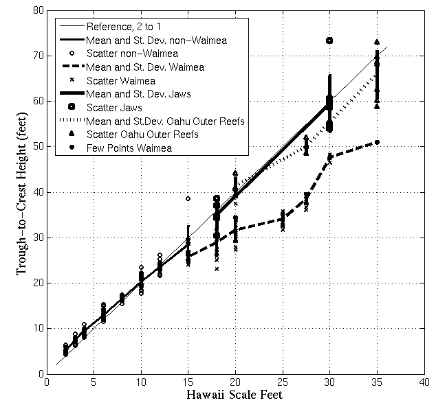
Reading up from the bottom, interpolating our aforementioned GC Set data point of 22 HSF for New Year's Day, 1973, hit the dashed line labeled "Mean and St. Dev. Waimea," and, lo and behold, a new corrected answer is spit out and it looks like maybe 32 or 33 real-world feet, with a presumed error bar that can take you a little ways from there, in either direction.
Still definitely in the "overhead" size classification, but nothing at all like what a simple doubling of the original 22 HSF gave us.
I feel vindicated in several ways, and although it still seems quite a bit bigger than I remember things being that day, I shall content myself with the new result.
I going to leave the erroneous content of the first Addendum right where it sits, by way of a cautionary tale for those who might think they have answers, when in fact they do not, with myself at the head of that unfortunate list.
Hopefully, this is the end of this silliness. It's gone on for too long already, and I for one will be glad to see an end to it.
Return to 16streets.comHawaii Stories - Table of ContentsContact Email Link |